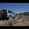
SRN Posted June 15, 2011 Share Posted June 15, 2011 Day 1 Friday started off by meeting up with Joseph at about 10:30am and making the journey to Moab where we stopped for lunch at Pasta Jay’s. After topping off our tanks at the edge of town we continued on until we hit dirt off UT 211 at the beginning of the Cottonwood Canyon Road around three in the afternoon. Here we aired down and took one last look at pavement for the next few days. Always an enjoyable thing! We blasted down the Cottonwood Canyon Road and the beginnings of the Beef Basin Loop as we worked our ways to the Beef Basin wash and our first campsite. Both my copilot Scott and I reflected that the Pathfinder was pure luxury on these rutted/washboard roads in comparison to the Samurai. I knew it would be so, but wow. Getting out of the car after awhile on these roads didn’t feel like hitting solid ground after a bombing run over Berlin! Anyway, the wash road was fine until we hit the first creek crossing. Here the heavy rains we’ve been having had made for an interesting crossing. All the tracks stopped here and there was no evidence of traffic on the other side. Well, since we were “gangsta expo” as Joseph noted, we didn’t view this as much of a hinderance. So I popped the Pathfinder in 4-low for the first time in anger and headed down the relatively steep, very soft sandy hill into the creek bed and up the other side with no issue. Joseph followed with the Ultimate KJ idling like a turbo diesel should and we headed off into the overgrown trail to find camp. The trail had a few other sections that had been washed out a bit by the rains, but nothing too bad. It was fun to finally have the Pathfinder in 4-low and using it for what it was designed for though. We eventually made camp at about six or so and set about making ourselves comfortable. For Joseph this entailed setting up his slick ARB awning. For a rugged Australian this takes but 30 seconds. For Americans, two people and a bit longer. After setting up camp we just relaxed, took in the scenery and enjoyed a campfire under the clear night sky. Photos courtesy of Stephen Nielson and Scott Curtis Link to comment Share on other sites More sharing options...
SRN Posted June 15, 2011 Author Share Posted June 15, 2011 Day 2 Morning broke bright and warm and we lounged in the sun for a bit before getting underway around 10. We worked our way back out through the wash to the first creek crossing and I dipped into it like it was no big deal. Well I quickly found that the sandy hill was much softer than I had expected and boulders at the bottom prevented me from first getting the downhill momentum I need and second from backing up. This is one of those moments when you thing about those parts you have sitting at home that could have made this a non-issue. Like the Limited Slip left uninstalled that would have aided greatly in getting back over the boulder... After a few attempts to get out on my own, it was time to throw the recovery strap back to Joseph and the diesel beast of his. With a little tug and some tire spin the Pathfinder was free and we moved the offending boulder out of the way and we were in business again. We spent the rest of the morning exploring the Beef Basin Loop and some spurs off it and looking at ruins. Photos courtesy of Stephen Nielson and Scott Curtis Link to comment Share on other sites More sharing options...
SRN Posted June 15, 2011 Author Share Posted June 15, 2011 The second camp was planned to be at a location in the Butler Wash area that was a short hike to a spectacular overlook of the Needles District of Canyonlands. We spent several hours going up and down every spur road in the Ruin Park area looking for the right one to get us there. We could see the spot we wanted to be from the main road, but the only road that seemed to head to it was also the only one with a “Road Closed” sign. According to my BLM map of the area, that road skirts the edge of the Butler Wash WSA and I guess since the last time I was there in 2009 the BLM has decided that the road is now in the WSA. I was disappointed, but the camp we chose did have some nice ruins up in the cliff surrounding it. We spent another pleasant night around the campfire and had a lively discussion regarding how “expo ready” our gear was. Personally, I think our hot dog sticks are just as good as any titanium and leather handled ones on the market today! Photos courtesy of Stephen Nielson and Scott Curtis Link to comment Share on other sites More sharing options...
SRN Posted June 15, 2011 Author Share Posted June 15, 2011 Day 3 I awoke Sunday morning excited about getting to the “hard” part of our trip through Canyonlands via Bobby’s Hole and out Elephant Hill. So after tea and breakfast we broke camp and bit farewell to Ruin Park. Bobby’s Hole is a moderately steep hill made up of some ledges, boulders and loose dirt. Nothing too technical, but certainly entertaining to crawl down. I was throughly impressed with the Pathfinder gearing as it idled down with no issues. From Bobby’s Hole we continued on to the Canyonlands boarder and into the always stunning Needles District. Along the way we stopped for some “expo ready” poser shots and to check out some petroglyphs. Photos courtesy of Stephen Nielson and Scott Curtis Link to comment Share on other sites More sharing options...
SRN Posted June 15, 2011 Author Share Posted June 15, 2011 After our stop at the petroglyphs we quickly came upon SOB Hill. Now SOB Hill has been in various states each time I’ve encountered it. Way back in 1994 with my dad it was considered an optional obstacle on the Elephant Hill trail during the Easter Jeep Safari. Now being in a stock Samurai at the time my dad had no issues getting over the ledges, boulders and making the very tight turn. The second time a few years ago the Park Service had filled in most of the hill and the only difficult part was tight turn. This time around the hill had returned to presenting a bit of a challenge with a climb up loose dirt and rocks to the sharp turn through the cut in the rocks. I had a few points where I again regretted no installing the LSD before I left, but nothing that couldn’t be over come with backing up and changing my line. Again, I was very happy with the Pathfinders stock gears and grateful for the OME suspension. Joseph, demonstrating that true players only drive diesels, idled over the whole thing without an issue. From this point we were on the Elephant Hill loop and with moseyed along over small ledges and creek crossings. When we finally reached Elephant Hill I forgot, for some reason, how extreme the switchbacks are. Practically parallel in some spots. My mind always remembers the first time in my dads Samurai and how it wasn’t even an issue to make the turns. Now in a Pathfinder what had been a three point turn in the Samurai turned into a five or six pointer at some spots. Nothing hard, just a few more forwards and backs. The hill is a fairly steep climb heading up a few hundred feet over ledges and a bit of slick rock at the top. Since you’re moving all the time and it pays not to stop for photo ops I only have one picture of Joseph and the very top. But hey, what a way to close out the photos! The Ultimate KJ rumbling up the famous Elephant Hill: And that was it. We dropped down the other side into the parking lot, aired up and headed back into Moab where we stopped at the Moab Brewery for the obligatory bread bowl of beer cheese soup (don’t ask Joseph about the service though). It was a great trip and a great way to break the Pathfinder in as my new expedtion/overlanding/camping vehicle. I can’t wait to get out again. Photos courtesy of Stephen Nielson and Scott Curtis Link to comment Share on other sites More sharing options...
thehuntersam Posted June 16, 2011 Share Posted June 16, 2011 (edited) Sounds like a great trip!I need to get my off my butt and go down to southern utah more! Edited June 16, 2011 by thehuntersam Link to comment Share on other sites More sharing options...
SRN Posted June 16, 2011 Author Share Posted June 16, 2011 (edited) It was a good time. I probably won't be heading that way again until the fall as its starting to get roasty. My next trip will likely be up to Vipont in northwestern Utah. It's supposed to be a pretty nifty ghost town abandoned in 1991 up at about 10,000 feet. I will again post up about it before I go. The next southern trip will probably be in October to Blue Notch. Edited June 16, 2011 by SRN Link to comment Share on other sites More sharing options...
Recommended Posts
Create an account or sign in to comment
You need to be a member in order to leave a comment
Create an account
Sign up for a new account in our community. It's easy!
Register a new accountSign in
Already have an account? Sign in here.
Sign In Now